Skip to content
  • EUROPEAN SPACE AGENCY
  • Overview
  • Portfolio
    • Product Brochure
    • EO4SD in “Action” (beta)
  • Where we Work
    • Supported Initiatives
  • Consortium
    • Partner Description
  • Contacts
  • News
  • Knowledge Portal
    • Webinars
    • World Bank Workshop 2020
  • Storylines
    • Global Urban Growth Dynamics Monitoring
    • Mapping and monitoring urban green areas
    • City Land Assets Structure and Evolution
  • About

urban development

earth observation for sustainable development

EO4SD-Urban
  • EUROPEAN SPACE AGENCY
  • Overview
  • Portfolio
    • Product Brochure
    • EO4SD in “Action” (beta)
  • Where we Work
    • Supported Initiatives
  • Consortium
    • Partner Description
  • Contacts
  • News
  • Knowledge Portal
    • Webinars
    • World Bank Workshop 2020
  • Storylines
    • Global Urban Growth Dynamics Monitoring
    • Mapping and monitoring urban green areas
    • City Land Assets Structure and Evolution
  • About
Menu Close
Read more about the article Webinar 2.2 – Basics of Image Classification & Geographical Information Systems

Webinar 2.2 – Basics of Image Classification & Geographical Information Systems

  • Post published:September 26, 2018
  • Post category:News

Join us for a webinar on Sept 26, 2018 at 2:00 PM CEST (duration 1 hour): Register now! The webinar answers the questions: How can I generate information from satellite…

Continue ReadingWebinar 2.2 – Basics of Image Classification & Geographical Information Systems
Read more about the article Webinar 2.1 – Remote Sensing Introduction & Characteristics of Satellite Data

Webinar 2.1 – Remote Sensing Introduction & Characteristics of Satellite Data

  • Post published:September 18, 2018
  • Post category:News

Join us for a webinar on Sept 18, 2018 at 2:00 PM CEST (duration 1 hour): Register now! The webinar answers the questions: What is remote sensing? What is a…

Continue ReadingWebinar 2.1 – Remote Sensing Introduction & Characteristics of Satellite Data
Read more about the article Repeat of EO4SD Webinar 1.1 – Geospatial Technology and its Applications for Urban Topics

Repeat of EO4SD Webinar 1.1 – Geospatial Technology and its Applications for Urban Topics

  • Post published:August 28, 2018
  • Post category:News

Join us for a webinar on Sept 12, 2018 at 3:00 PM CEST (duration 1 hour): Register now! The webinar will present some of the major challenges in urban development…

Continue ReadingRepeat of EO4SD Webinar 1.1 – Geospatial Technology and its Applications for Urban Topics
Read more about the article Integration of EO4SD-Urban geo-spatial products in World Bank studies

Integration of EO4SD-Urban geo-spatial products in World Bank studies

  • Post published:August 1, 2018
  • Post category:News

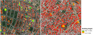
The EO4SD-Urban in Phase 1 of its implementation (2016-2017) had the pleasure to collaborate with two dynamic and interesting projects from the World Bank (WB) based in Africa. In particular,…

Continue ReadingIntegration of EO4SD-Urban geo-spatial products in World Bank studies
Read more about the article EO4SD Webinar 1.1 – Geospatial Technology and its Applications for Urban Topics

EO4SD Webinar 1.1 – Geospatial Technology and its Applications for Urban Topics

  • Post published:July 16, 2018
  • Post category:News

Join us for a webinar on Jul 17, 2018 at 10:00 AM CEST (duration 1 hour): Register now! The webinar will present some of the major challenges in urban development…

Continue ReadingEO4SD Webinar 1.1 – Geospatial Technology and its Applications for Urban Topics
Read more about the article EO4SD-Urban @ World Bank Land & Poverty Conference 2018

EO4SD-Urban @ World Bank Land & Poverty Conference 2018

  • Post published:March 27, 2018
  • Post category:News

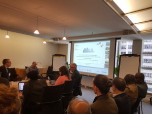
GAF AG, GISAT and SIRS from the EO4SD Urban Consortium attended the World Bank Land & Poverty Conference 2018 and showed the results of the collaborative work carried out in…

Continue ReadingEO4SD-Urban @ World Bank Land & Poverty Conference 2018
Read more about the article Predicting slum dwellers’ deprivations from space: a pilot study on Dhaka (Bangladesh)

Predicting slum dwellers’ deprivations from space: a pilot study on Dhaka (Bangladesh)

  • Post published:September 25, 2017
  • Post category:News

One of the most pressing development challenges in today’s world of rapid urbanization is how to respond to the unmet demand for basic infrastructure services, like adequate housing, clean water…

Continue ReadingPredicting slum dwellers’ deprivations from space: a pilot study on Dhaka (Bangladesh)
Read more about the article Supporting the local urban planning process in Kolkata (India)

Supporting the local urban planning process in Kolkata (India)

  • Post published:August 21, 2017
  • Post category:News

In line with the Millennium Development Goals, Indian Prime Minister Modi launched three major urban development initiatives in June 2015 which are handled by the Ministry of Urban Development (MoUD),…

Continue ReadingSupporting the local urban planning process in Kolkata (India)
Read more about the article Mapping the most recent flood events in Dhaka (Bangladesh)

Mapping the most recent flood events in Dhaka (Bangladesh)

  • Post published:August 14, 2017
  • Post category:News

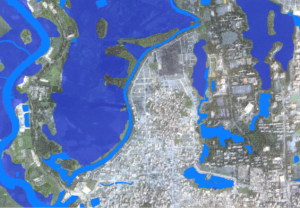
In August 2017, the EO4SD-Urban Consortium was able to provide fast and valuable support to the city of Dhaka, Bangladesh, which faced intense flooding. These events, despite not the largest…

Continue ReadingMapping the most recent flood events in Dhaka (Bangladesh)
Read more about the article Completion of Phase 1

Completion of Phase 1

  • Post published:July 3, 2017
  • Post category:News

The EO4SD-Urban Consortium successfully finalized Phase 1 of the project at the end of September 2017. So far, more than 200 products have been generated for 16 Case Studies (covering…

Continue ReadingCompletion of Phase 1
  • Go to the previous page
  • 1
  • 2

Disclaimer | Legal Notice | Privacy Policy

EO4SD - Urban Development is a project funded by ESA under the ESA Earth Observation Envelope Programme EOEP-4. The view expressed herein can in no way be taken to reflect the official opinion of ESA.
  • EUROPEAN SPACE AGENCY
  • Overview
  • Portfolio
    • Product Brochure
    • EO4SD in “Action” (beta)
  • Where we Work
    • Supported Initiatives
  • Consortium
    • Partner Description
  • Contacts
  • News
  • Knowledge Portal
    • Webinars
    • World Bank Workshop 2020
  • Storylines
    • Global Urban Growth Dynamics Monitoring
    • Mapping and monitoring urban green areas
    • City Land Assets Structure and Evolution
  • About
Type your search
Manage Cookie Consent
Wir verwenden Cookies, um unsere Website und unseren Service zu optimieren.
Funktional Always active
The technical storage or access is strictly necessary for the legitimate purpose of enabling the use of a specific service explicitly requested by the subscriber or user, or for the sole purpose of carrying out the transmission of a communication over an electronic communications network.
Preferences
The technical storage or access is necessary for the legitimate purpose of storing preferences that are not requested by the subscriber or user.
Statistics
The technical storage or access that is used exclusively for statistical purposes. The technical storage or access that is used exclusively for anonymous statistical purposes. Without a subpoena, voluntary compliance on the part of your Internet Service Provider, or additional records from a third party, information stored or retrieved for this purpose alone cannot usually be used to identify you.
Marketing
The technical storage or access is required to create user profiles to send advertising, or to track the user on a website or across several websites for similar marketing purposes.
Manage options Manage services Manage {vendor_count} vendors Read more about these purposes
Einstellungen anzeigen
{title} {title} {title}