The EO4SD-Urban Consortium successfully finalized Phase 1 of the project at the end of September 2017. So far, more than 200 products have been generated for 16 Case Studies (covering a surface of ~29.000 km²) and provided to both users of the Multi-Lateral Development Banks (MDBs) and their counterpart City Authorities. In particular, all of them proved of high quality as confirmed by overall accuracies ranging from 85% to 90%.
Products have been delivered using a standardized map layout for the different thematic layers. Furthermore, City Operation Reports including additional technical information have been also delivered for all Phase 1 test sites. Specifically, they describe the adopted Land Use/Land Cover (LU/LC) nomenclature, the EO data used, the methodologies employed in the production stage, as well as accuracy assessment details including the selected Quality Control (QC) approach and basic statistics.
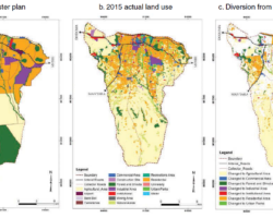
Examples of integrated analyses that can be undertaken with the provided geo-spatial data have been also supplied to the MDBs and end users. Among others, these include for instance the assessment of urbanization and LU/LC change occurred in both core and peri-urban areas over time, as well as the flood risk estimation. Initial user feedback on the overall utility of the delivered products has been very positive and provides the impetus for a continuation of work into Phase 2.