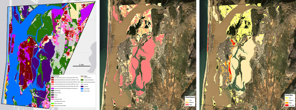
Located along the north coast of Senegal, the unique geographical position of Saint-Louis, at the mouth of the Senegal river, exposes the city to major environmental threats, including floods, coastal erosion, and rise of the sea level. The EO4SD-Urban initiative supported city of Saint-Louis in the framework of the Global Platform for Sustainable Cities (GPSC) GEF (Global Environment Programme), producing satellite-based information on floods. The produced maps reflecting the historical flood occurrence frequency, the associated flood hazard and flood risk, and up to date land use and land cover (LULC) will reinforce the establishment of climate-resilient urban planning and sustainable urban development.
Mapping of flood events over the last 10 years for Saint-Louis urban and peri-urban areas, based on high-resolution (Sentinel, Landsat) and very high-resolution imagery (as available through e.g. Google Earth), led to the description of flood occurrence. Flood hazard categorises the flooding probability, whereas flood risk results of the combination of the probability of a flood event and its possible consequences. It takes advantage of the new LULC derived from Earth Observation data for both 2018 and 2006.
Results show that approximately 20% of the core urban area is classified as high-hazard areas, and about 45% of the larger urban region is flood-prone. These products are expected to trigger further flood vulnerability analysis and support Senegalese governmental agencies and local authorities in adapting urban policies and urban planning to the upcoming environmental challenges.


